The SIMIB Project
Monitoring Information System of Forest Fires
This project was created so as to increase the use of new technologies at the service of the National Forest Corp and the public bodies that in compliance with the 353/2000 outlain law have the task of estimating the demages at the end of the season and drawing up the cadastre of the burned woodlands and pasture lands.
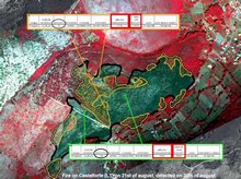
False colour aerial images of the forest fires registered in Lazio region in 2004 were acquired with the use of the DFR (Duncan-Flir-Riegl) system and returned through a quick orthorectification process at a geometric accuracy of less than 2 m in X and Y, with which it was possible to discriminate burned areas of just 1000 m².
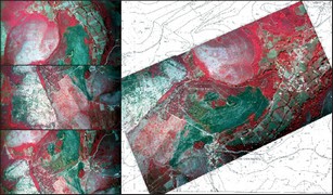
Experimented technology allows us to obtain a large scale survey thereby avoiding the economic and technical limitations imposed by the GPS survey or made by aerial standard photogrammetric cameras.
After the process of photointerpretation, the burned areas were digitalized discriminating the wooded and the agricoltural/urban parts, and overlaid upon the cartography of SIM, Information System for the Mountain Environment, making it possible to extract the parcels which had been partially or wholly affected by the fire.
For more details see the papers (in italian):
Progetto SIMIB: mappe degli incendi e valutazione dei danni da oggi a portata di mouse - SILVAE, rivista tecnico-scientifica del CFSIl telerilevamento aereo multispettrale per la mappatura degli incendi boschivi - MONDOGIS n. 64 feb. 2008
| Il sistema informativo SIMIB - clicca sulle immagini per ingrandire | |
|
|