VITIMAP - advanced services for precision viticulture
VITIMAP is a package of integrated services for precision viticulture which is based on remote sensing high resolution images, acquired by aircraft or satellite.
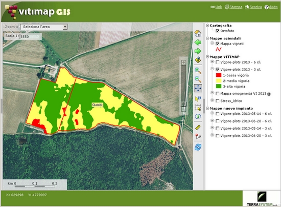
In recent years Terrasystem has partnered several research institutions in projects of precision viticulture, including CNR Ibimet, CRA-VIC, CRA-ENC and the Universities of Tuscia, Palermo, Turin and Foggia. During these experiences specific methodologies for the acquisition of multispectral images by aircrafts and techniques of data processing have been studied and developed. Specific vegetation indexes to process digital maps of the vigor and water stress have been defined, as have maps of production and eno-chemical parameters, including exposed leaf surface, total sugars, titratable acidity, content in polyphenols and anthocyanins, average weight of the bunches. In 2013, in collaboration with Marchesi Antinori srl, a further line of study on the analysis of the plots in pre-implantation stage has started.
The data (images) used to produce the VITIMAP maps are acquired by the aerial systems of Terrasystem DFR and ASPIS by means of true colour, multispectral and thermal cameras . The multispectral data can be acquired, in alternative, with a high resolution satellite.
Since the activation of the service in 2010, with VITIMAP, maps of the vigor of more than 1,000 vineyards of thirty companies in Tuscany, Umbria, Piedmont, Veneto, Puglia and Sicily were processed. Since 2013, maps of the water stress of the vineyards were also provided .
VITIMAP offer details.
Customers of VITIMAP service since 2010