Aerial data capture
TERRASYSTEM uses airborne systems for the acquisition of multispectral and thermal
images, for altimetric contours surveying and for the analysis of atmospheric gases and pollutants.
These systems, featuring ease of use, cheapness and flexibility, were developed
and have been constantly updated by TERRASYSTEM in close collaboration with a research team that involves Universities and
Research Institutes.
The use of the aerial platform, wich is both simple and versatile, provides data survey at the regional scale in very high resolution, which can be used in the monitoring and management of environmental resources. Skilled technicians and operators follow all the stages, from the definition, planning and carring out of the flight, up to the distribution of the acquired data.
Products and services
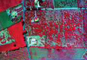
- Aerial images with submetric resolution by digital multispectral system in selectable bands (400-1000 nm)
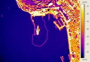
- Thermal IR aerial images by FLIR System
- High frequency altimetric contours with laser altimeter
- Data of fluxes of gases and atmosferic pollutants
|
DFR images composition 2004 flight Foce dell'Ombrone (GR) click to open animation |
|