Environmental monitoring
For reasons of scale, cost, timing and complexity, the use of remote-sensed data has long since become essential in environmental surveying. This approach allows the user to survey ever-increasing quantities of data as well as being able to make generalisations from the acquired data.
Combining the techniques of field survey with the ones of aerial and satellite remote sensing, TERRASYSTEM is able to survey, process and manage environmental and territorial data within geographic information systems or decision support systems.
Product and services
- Agricoltural and forest monitoring (pathology, productivity, stress etc.)
- Precision farming
- Forest fire geographic information system
- Temperature and thermography maps
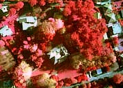
- Urban green monitoring
- Natural hazards monitoring
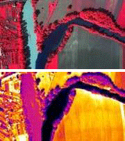
- Monitoring of coasts, rivers, basins
- Land use and land cover maps
- Monitoring of buildings and industrial sites
- Updating of cartography, quick cartography