Mapping of hazelnut in the North of Turkey
Turkey is the major producer of hazelnuts, alone produces about 70 % of the world production; nevertheless accurate and updated data relative to the extension of hazelnut cultivation in this country does not exist.
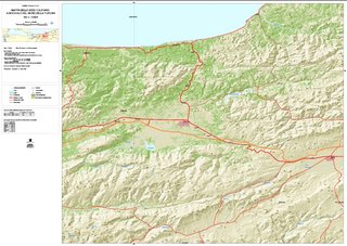
The goal of the project was, therefore, to draw up a map scale 1:100.000 of the hazel groves of the North of Turkey by a supervised classification of average resolution remote sensed images.
The studied regarded a band which extended from the Istanbul province to the East border with Georgia.
The various steps of the work concerned:
- Preliminary processing of images: georeferencing, orthorectification and atmospheric correction;
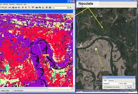
- Study of the areas by mean of high resolution images available on Google Earth;
- Ground campaign for collecting data and filling a database. More than 2000 GPS points were collected, shared out between hazelnut class, other tipologies of vegetation and topographies, associated with other information such as coverage indexes, site extension etc.;
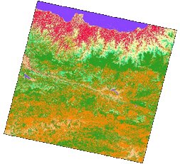
- Supervised classification of satellite images supported by the analysis of other informative layers.
All the most commonly employed classifiers (hard and soft) were tested; the average accuracy of the final map, relatively to the hazelnut class, was 80%. As well as the map, statistics were produced relating to the distribution of hazelnut cultivation in relation to other environmental variables and administrative boundaries. The final classification was represented in 9 pdf maps scale 1:100.000.
click on the image to enlarge