 Aerial data capture flyer
Aerial data capture
Aerial platforms
- Sky Arrow 650 TC/TCNS
Light aircraft, alternatively equipped with DFR, FLIR or ASPIS systems -
Piper PA-34 Seneca II
P68 Observer Vulcanair
Light twin-motors, they can house at the same time the DFR (with FLIR) and ASPIS systems
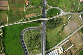
- real colour images
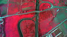
- multi-spectral images
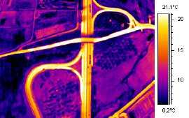
- thermal images
- elevation profiles
The use of a light and versatile aerial platform, provides survey at the regional scale in very high resolution, which can be used in the monitoring and management of environmental resources.
TERRASYSTEM directly looks after all the stages of data production, from the planning
and execution of the flight until the distribution of the product, ready for use.
The pre-processing of the images is achieved through specific software which can perform:
- Quality control of the acquired data through automated tools
Geometry of the coverage of the acquired images, lateral and longitudinal overlap between images, handholds map - Geometric correction (orthophoto) and mosaicking
Direct geo-referencing by GPS/IMU data - Radiometric correction of multispectral data
- Map of the angles of view of the image (azimuth and off-nadir)
View and download some sample products
TERRASYSTEM, beyond the simple acquisition / pre-processing service, provides packages of integrated services that include further processing of the data to various levels, to support specific applications (follow the links for more details):