 Forest fires cadastre flyer (ita)
Forest fires mapping
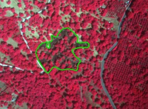
Terrasystem produces maps of the forest fires on the basis of images acquired ad hoc by its airborne multispectral DFR system. The methodology has been validated by the University of Tuscia of Viterbo within the SIMIB project.
The service includes:
- Acquisition of multispectral aerial images of the burned areas on the basis of reports from the competent authorities (CFS, civil protection, etc.).
- Orthoprojection, photointerpretation of the images, and editing of the burned areas sha pes
- Extraction of the cadastral data of each burned area and creation of a geodatabase.
Platform for the data acquisition
A light aircraft characterised by high flexibility, allows for:
- the acquisition of sub-meter resolution multispectral data, pushing the operational limits of the GPS survey.
- an immediate survey upon the occurrence of the event
- the low cost of the survey, which is targeted exclusively to the areas affected by the fire
DFR system (Duncan-Flir-Riegl)
- Multispectral images by selectable spectral bands
- Images in true colours
- Thermal images
- GPS data
- Laser-altimetre data
Image processing
- Orthoprojection with less than one meter geometric resolution
GIS processing
- Burned areas map in a cartographic framework
- Extraction of cadastral data
- Implementation of a geographic database