Mapping of forest phytopathies: PRAL - Chestnut project
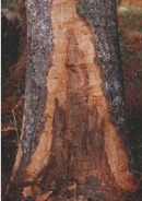
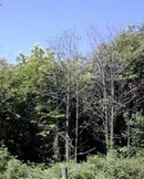
Monitoring of the ink disease
This research project was carried out with the aim of developing new technologies for the monitoring of phytopathies in forest environment, through remote-sensings methodologies integrated with geographic information systems.
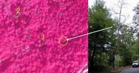
High resolution multispectral images obtained with the airborne digital sensor ASPIS (Advanced Spectroscopic Imaging System) were employed to map ink disease centres and affected areas.
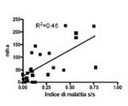
Thematic maps representing the spread of the pathogen in the district of Cicolano (Rieti) were obtained by photointerpretation, allowing us to estimate with a very high level of precision the estension, the growth in a two years period and the distribution of the disease over an area of more than 2000 hectars.
The integration of the GIS with further informative layers allowed us to highlight correlations between the localization of the diseased plants and environmental parameters as exposure, altitude, slope, influence of viability and compluviums.
For more details see the paper (in italian): Individuazione di tecniche innovative per il monitoraggio del ?Mal dell?inchiostro? del castagno su scala comprensoriale - Atti della 9ª conferenza nazionale ASITA 2005