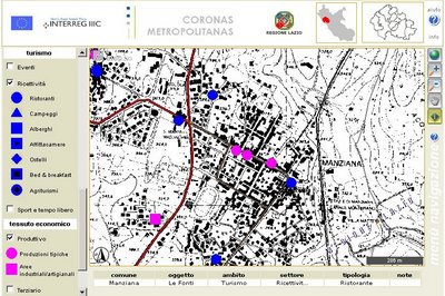
WebGIS of CORONAS METROPOLITANAS
The Web-GIS is an application developed to promote the contents of the Interreg project "Coronas Metropolitanas", that has among its goals the singling out, or elaboration, of strategies to re-balance the lands around large urban areas, in particular the development of a transportation system functional to the valorization of the local resources, both touristic and productive.
The GIS has a double character: it is intended to spread the knowledge about the land resources as well as to function as a survey tool in support of land policy and planning.
The contents of the project are shared by a graphic interactive interface to anyone
who might be involved subjects, such as citizens, private operators and public administrations.
The Web-GIS presents, other than the map navigation tools, some research tools that can make any research focusing on certain categories of resources, places of interest or services particularly effective.
The application is developed in Microsoft environment using the .NET framework and SQL-Server 2005, and it has the software AspMap of VDS Technologies as a GIS engine.
link to the WebGIS of Coronas Metropolitanas
For more details see the paper (in italian): Nuove tecnologie per la realizzazione di sistemi informativi territoriali web-oriented, due casi applicativi: i progetti CORONAS METROPOLITANAS e GEOBIC - Atti della 10ª conferenza nazionale ASITA 2006