GEOBIC WebGIS
GeoBIC is an application developed with the aim of supplying online consulting services to companies. It allows consulting demographic, social and economic data obtained from official statistical sources, so as to have better knowledge of the territorial background for operators who wish to start a new activity or already have their own company.
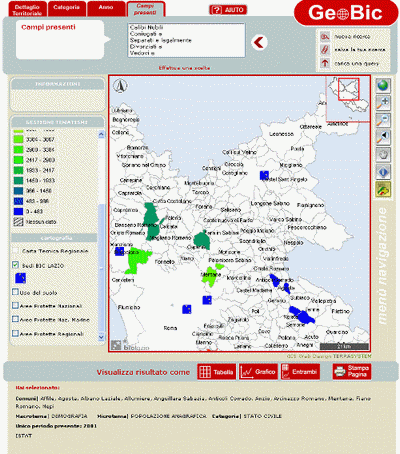
GeoBIC has among its characteristics a facilitation in reading data given by a geographic representation that accompanies the traditional tool of query on relational database, enriching the obtained information with spatial references.
This application allows the user to perform a research selecting in a dinamic form the territorial ambit that he intends to analyze (region, province, communes), several avalaible themes (land, demography, social context, tourism, etc.) up to detail categories.
The map gives the result in graphic form and it is endowed with interactivity tools that allow to integrate the input data: it is possible for example to add directly from the map one or more commons to the territorial ambit already selected.
The search output is visualized on table and istogrammes and it is traslated directly on the map under the form of a statistical graph:
the colors of a graduated palette match the value intervals.
GeoBIC is developed in Microsoft environment using the .NET framework and SQL-Server 2005, and
it has the software AspMap of VDS Technologies as a GIS engine.
For more details see the paper (in italian): Nuove tecnologie per la realizzazione di sistemi informativi territoriali web-oriented, due casi applicativi: i progetti CORONAS METROPOLITANAS e GEOBIC - Atti della 10ª conferenza nazionale ASITA 2006